Case Study: Trees Need Trimming? There’s an App for That
July 6, 2021
Dan Hicks, director of operations for the Parks Department for the city of Moncton, New Brunswick, Canada, oversees several city assets from municipal arenas to forestry. Every municipality has standard operating procedures, and when elements of these processes are automated, efficiency and reliability grow.
Hicks and his team correctly predicted that a certain routine maintenance task — identifying and recording low-hanging tree branches — was ripe for automation. A hazard to vehicles and pedestrians alike, low-hanging tree branches require continual identification and removal to ensure people can safely navigate the city. In the city of Moncton, tree branches must be 15 feet above street level and 8 feet above sidewalks.
When Hicks describes the traditional method of recording low-hanging tree branch locations, the opportunity for improvement became evident.
“We did it before by driving by, jotting down addresses and identifying low-hanging branches by eye,” Hicks says. “It’s time-consuming when you do it that way: using pen and paper and driving. Drive, stop, write it down. Drive, stop, write it down.”
Hicks and his team knew a more automated solution was possible. They asked a local technology distributor, who assured Hicks that they could figure something out.
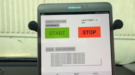
What they came up with is a simplified mobile scanning device made up of three basic elements. Attached to a company vehicle, a small lidar unit measures the clearance to the nearest solid overhead structure while a special antenna captures the vehicle's horizontal location to sub-meter accuracy. A Samsung tablet using a customized software application handles the data from these two elements and delivers the output file.
The GNSS service turns the Samsung tablet into a fully functioning GNSS receiver, providing positioning at submeter accuracy without the expense of traditional GNSS equipment. Using a tablet (or smartphone) as a GNSS receiver makes this setup more approachable for employees who have no experience using survey equipment.
Anyone who is familiar with a smartphone can navigate the software on their Android device. The small antenna and lidar unit are mounted by suction cups, making the setup easily transferable between company vehicles.
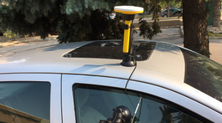
“You can put it on a golf cart and measure clearances on sidewalks,” Hicks says, adding that the device can be mounted to just about any type of vehicle. In Moncton, the setup is attached to the foreman's truck, and he gathers the tree data as a supplemental task to his normal duties.
When the drive is over, the customized application exports a comma-separated-values (CSV) point file to the city’s GIS technicians, who upload the data to a city map in Esri ArcGIS. Hicks and his team review the map and then filter and sort the conflict areas as high-, medium- and low-risk sites. The GIS map allows them to assess and schedule the maintenance of these conflict areas most efficiently, so they can attend to high-risk sites before they become a problem for motorists.
Hicks and his team are enthusiastic about the prospects of this new solution, offered by Trimble. Its simplicity allows employees without GNSS expertise or forestry knowledge to use it, which means purposeful, non-specialized work is available to more people.
“You're looking at a municipality with 650 employees, and at any given time some of them are on modified duty,” Hicks said. “They might be able to drive a truck but not lift a chain saw, so we need productive work for them to do.” The ease of use makes this a task that any employee capable of reading a tape measure and driving can perform successfully.
The GNSS capability provided by the technology also allows flexibility in planning when gathering data, without a substantial investment upfront. “One could collect data several (miles) per day,” Hicks said. It’s an upgrade that will benefit both the employees of Moncton and the citizens they serve.
Gordon Wilson is a professional land surveyor and writer in Portland, Oregon.
Next
Read next on FacilitiesNet